Landscape Explorer shows how much the American West has changed
With the click of a mouse, a new mapping tool shows how places in the American West have changed over the last 70 years.
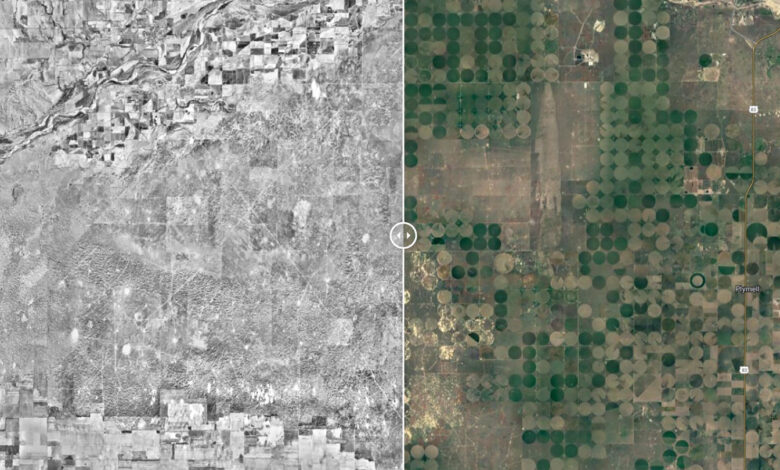
With just a Web browser, anyone can open Landscape Explorer, which will pull up a modern Google map of the United States beside a black-and-white aerial image of the western states circa 1950. A slider button allows for scrolling back and forth between past and present.
You can type a place or address into the search bar, then zoom in or out. Search for “Lake Powell” and watch the Colorado River’s red rock canyons of the past turn into a reservoir. Type in “Las Vegas” and see Sin City’s sprawling grid of streets disappear into desert arroyos as you swipe back in time.
The free tool is an easy way for anyone with an interest in the American West to peruse the past. But Landscape Explorer also has a loftier purpose: helping government agencies, landowners and conservation professionals make complex decisions about how to manage land.
The powerful visual contrast between the historical snapshot and modern-day satellite imagery “allows us to go from zero to 100” in terms of understanding ecosystem changes, says Scott Morford, an applied spatial ecologist at the University of Montana in Missoula who led the development of Landscape Explorer. The project was supported by Working Lands for Wildlife, a conservation initiative led by the U.S. Department of Agriculture, and other partners. The impetus, Morford says, was to “give us a reference for how rapidly things are changing across biomes that we care about.”
Before Landscape Explorer, most collections of historical imagery of large-scale landscapes went back to only the 1980s. Finding earlier imagery of large landscapes was expensive and time-consuming. While some previous projects have stitched together historical imagery at small scales to look at how a particular watershed or county has changed, “the real revolution is that we were able to figure out how to do it at scale,” Morford says. “We wanted to make something that was universal and accessible” for everyone, not just remote sensing specialists.
Morford and colleagues processed about 170,000 aerial images that were taken by U.S. Army pilots during the Cold War and later digitized. To create a continuous mosaic, the team used specialized software to stitch together images of adjacent patches of land, the researchers explained in a paper published in July in Remote Sensing in Ecology and Conservation. The final step was pairing the mosaic with satellite imagery using Google Earth Engine.
Landscape Explorer began as a small project to assess the extent of woody encroachment onto grasslands in western Montana. Due to fire suppression, conifers like western juniper or eastern red cedar are taking over ecosystems that were historically treeless, such as sagebrush steppe and prairies. A monoculture of these water-guzzling trees is bad news for local biodiversity and increases the risk of catastrophic wildfire.
Third-generation Montana rancher Bruce Peterson says that seeing historical and current aerial imagery side by side made him realize how the steady infiltration of trees had devalued his family’s livestock pastures. “It’s a little bit like losing your hearing or your vision with these trees. They eat away a little of your land at a time, and then by the time you get hearing aids or glasses, you realize it’s gotten really out of hand,” Peterson says.
Using Landscape Explorer, Peterson and dozens of other landowners involved in the Southwest Montana Sagebrush Partnership have prioritized where to remove invading trees. The group has restored nearly 50,000 acres of treeless rangeland since 2020, according to the Nature Conservancy, a member of the partnership.
Landscape Explorer also helped the Clark Fork Coalition, a Montana-based nonprofit that protects and restores waterways, to see how urban and industrial development has impacted floodplains. “This tool gives us the power of time travel. It’s like a time-lapse showing all that’s been lost and where the continued pressure is very real,” says Karen Knudsen, the coalition’s executive director.
After seeing the successes in Montana, the makers of Landscape Explorer extended the tool to 17 states in the West to show where forests, grasslands or rivers are most at risk of disappearing and where intact habitats can still be preserved.
Since the expanded tool was released in September, researchers have used it to assess glacial retreat in the Pacific Northwest, measure the historical extent of sand dunes in coastal California and pinpoint where wetlands have dried up. Morford is excited to see all the ways Landscape Explorer can help land managers. “It’s going to be used in ways we haven’t even thought of yet.”
Source
